The Most Scenic Bali Helicopter Flight Path: Seminyak to Uluwatu
- It covers approximately 25 kilometers of iconic coastline in under 15 minutes.
- The flight offers perspectives of Kuta’s surf, Jimbaran’s fishing fleets, and the Bukit Peninsula’s limestone cliffs.
- It culminates with a dramatic orbit of Pura Luhur Uluwatu, perched 70 meters above the Indian Ocean.
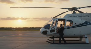
The gentle thrum of the Airbus H130’s main rotor becomes a steady, reassuring pulse against the humid Bali air. We lift vertically, a sensation less like flying and more like the island itself is receding beneath us. The manicured lawns of a Seminyak helipad shrink to a perfect green square, and in an instant, the tangled traffic of Jalan Raya Kerobokan is rendered a silent, intricate schematic. Below, the turquoise rectangles of private villa pools glitter like scattered sapphires. Then, the pilot banks gently to the south, and the entire coastline unfurls—a sweeping, sun-drenched panorama from the shores of Double Six Beach to the distant haze of the Bukit Peninsula. This is not merely travel; it is a recalibration of perspective.
The Departure: A New Perspective on Seminyak and Kuta
Lifting off from the Seminyak corridor, the first revelation is one of organized geometry. The dense matrix of luxury villas, boutique hotels, and world-renowned beach clubs like Potato Head and Ku De Ta creates a fascinating mosaic of modern leisure architecture. From an altitude of 1,500 feet, you can trace the evolution of this coastline, a development that exploded in the late 1990s, transforming sleepy coastal villages into a global destination. What takes 90 minutes to navigate by car during peak season is surveyed in its entirety in less than three minutes. The true value of a bali heli transfer becomes immediately, powerfully apparent.
As we track south, the iconic 2.5-kilometer arc of Kuta Beach comes into view. From this vantage, it’s not the chaotic energy of the beachfront that dominates, but the rhythmic procession of waves rolling in from the Indian Ocean. Tiny figures—surfers, waiting with inhuman patience for the perfect set—are scattered across the water. We see the runway of I Gusti Ngurah Rai International Airport (DPS) jutting into the sea, a reminder of the 23 million passengers who passed through in 2019. It’s a stark contrast to the island’s ancient heart. Further inland, glimpses of green hint at Bali’s agricultural soul, a landscape defined by the intricate Subak irrigation system, recognized as a UNESCO World Heritage site for its cultural significance.
Tracing the Coastline: Legian to the Jimbaran Isthmus
The flight path hugs the coast, providing a continuous, uninterrupted view of the shoreline’s subtle transformations. The high-energy beachfront of Legian bleeds into the more relaxed, family-oriented atmosphere of Tuban before we reach the dramatic curve of Jimbaran Bay. Our pilot, a 15-year veteran of Balinese airspace named Captain Made Sudarsana, points this out through the noise-canceling Bose headsets. “Here, you see the island’s geography in action,” he explains. “This is the isthmus, the narrowest point connecting the main island to the Bukit. From the ground, you just feel the road rise. From up here, you understand it.” The land bridge is barely 1.2 kilometers wide at its slimmest, a delicate tether for the massive limestone peninsula to the south.
Below, the placid waters of Jimbaran Bay are dotted with dozens of traditional jukung outrigger fishing boats, their colorful sails a vibrant contrast to the deep blue water. We can clearly identify the rows of famous seafood restaurants that line the beach, their tables and umbrellas appearing as tiny, colorful specks on the nearly 4-kilometer stretch of white sand. The clarity of the water allows us to see the dark patches of coral reef systems just offshore, ecosystems invisible to the beachgoer. This aerial cartography offers an appreciation for the island’s layout that no map can replicate, revealing the interplay between land, sea, and human settlement in exquisite detail.
The Bukit Peninsula: A Topographical Transformation
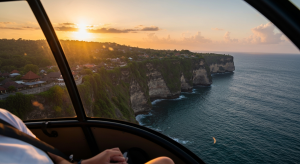
Crossing the isthmus, the landscape undergoes an immediate and dramatic metamorphosis. The flat, alluvial plains of southern Bali give way to the rugged, arid terrain of the Bukit Peninsula. The very color of the earth seems to change, shifting from the lush greens of rice paddies to the chalky whites and ochres of limestone. This is a different Bali, one defined by soaring cliffs and world-class surf breaks. As we fly over what is essentially a massive limestone plateau, the pilot expertly points out the legendary waves. First comes Balangan Beach, a crescent of sand framed by cliffs, followed by the iconic Dreamland. Then, we see the tight, rocky cove that houses Padang Padang, home to the prestigious Rip Curl Cup invitational, a surf contest that only runs when the waves meet a specific, formidable criteria.
The geology here is the star. The peninsula’s cliffs, which rise over 70 meters directly from the ocean, are the fossilized remains of ancient coral reefs, uplifted from the sea over millions of years. This unique topography results in a drier microclimate; the Bukit receives only about 1,000 millimeters of rain annually, less than half that of Ubud. According to the official geological surveys, this karst landscape is porous, which is why the area feels more arid and Mediterranean than the tropical heartland of Bali. Viewing this stark change from the air reinforces the incredible diversity packed into this one small island.
The Approach to Uluwatu: A Sacred Promontory
The culmination of this particular bali helicopter flight path is the approach to Pura Luhur Uluwatu. The temple seems to emerge from the rock itself, an extension of the cliff on which it is built. As we perform a slow, respectful orbit—maintaining a mandated altitude of at least 1,000 feet—the temple’s architectural brilliance is laid bare. Constructed from black coral rock, its tiered shrines and intricate carvings stand in sharp relief against the endless blue of the ocean. It is one of the Sad Kahyangan Jagad, the six key spiritual pillars of Bali, strategically placed to guard the island from the southwest. Its founding is attributed to the 11th-century Javanese sage, Empu Kuturan, with later additions by the revered priest Nirartha.
From our aerial perch, we can see the winding path along the cliff edge where visitors watch the sunset, and the stone amphitheater where the famous Kecak fire dance is performed nightly. “The temple’s placement is a masterclass in sacred geography,” commented Dr. Alistair Finch, a visiting professor of Southeast Asian studies I spoke with last year. “It’s positioned at the edge of the known world, a spiritual bulwark between the land and the vast, powerful ocean.” The flight provides a privileged view of this sacred space, capturing its scale, isolation, and profound spiritual resonance in a way that is simply impossible from the ground. It’s a moment of quiet awe, observing a 1,000-year-old sanctuary from a 21st-century marvel of engineering.
Beyond the Scenery: The Logistics of a Premier Flight
While the visual reward is immeasurable, the experience is underpinned by meticulous logistics and premier aviation technology. The helicopters typically used for these private charters, such as the Bell 429 or the aforementioned Airbus H130, are chosen for their safety, comfort, and exceptional visibility. Their spacious, air-conditioned cabins with plush leather seating and panoramic windows are designed for sightseeing, not just transit. A private charter for this specific Seminyak-Uluwatu route generally costs between $1,800 and $3,000 USD, depending on the aircraft and operator. While this is a significant investment, it re-frames the journey from a simple transfer into a pinnacle experience of a luxury itinerary.
Safety is paramount, with all reputable operators adhering to the stringent regulations of Indonesia’s Directorate General of Civil Aviation (DGCA). Pilots undergo rigorous training and possess thousands of hours of flight time specific to Bali’s unique weather patterns and terrain. This focus on professionalism ensures that the journey is as secure as it is spectacular. For those seeking to understand the full scope of aerial possibilities on the island, our Bali Heli Transfer: The Definitive Guide to Helicopter Travel in Bali provides a comprehensive overview of options. As affirmed by Indonesia’s official tourism board, Indonesia Travel, premium and experiential tourism are key to appreciating the nation’s diverse offerings.
Quick FAQ on Bali Helicopter Tours
What is the best time of day for this scenic flight? For photography, the “golden hour” just before sunset offers dramatic lighting and deep colors, casting long shadows from the cliffs. However, for the clearest visibility and the most vibrant ocean blues, a mid-morning flight between 9 AM and 11 AM is often recommended, as the daily haze has yet to build.
How long is the Seminyak to Uluwatu helicopter flight? The actual flight time is remarkably efficient, lasting approximately 12 to 15 minutes. The entire experience, from briefing to landing, typically takes about 30 minutes, covering a direct coastal distance of around 25 kilometers.
Are there flight restrictions over sacred sites like Uluwatu Temple? Yes, absolutely. Pilots operate under strict protocols when flying near any of Bali’s temples, or “Pura.” They must maintain a minimum altitude, typically 1,000 to 1,500 feet, and a respectful lateral distance to minimize noise and intrusion on the sacred space.
Can I customize my Bali helicopter flight path? Most charter services excel at creating bespoke itineraries. While the Seminyak to Uluwatu route is a popular and highly recommended scenic flight, you can easily arrange for detours over central Bali’s volcanoes, the Nusa Islands, or create a completely custom aerial tour based on your interests. This flexibility is a hallmark of a premium bali heli transfer service.
To witness the southern coastline of Bali from the air is to understand the island in a new context—to see the seamless blend of ancient topography, sacred architecture, and modern luxury. The Seminyak to Uluwatu flight is more than a time-saving convenience; it is a curated aerial exhibition, a highlight reel of Bali’s most dramatic coastal features. It transforms your perception of distance and scale, leaving you with a profound appreciation for the island’s majesty. To arrange your own bespoke journey and see the Island of the Gods from its most commanding viewpoint, explore the charter options available through Bali Heli Transfer Discovery. This isn’t just a way to travel; it’s the definitive way to see.